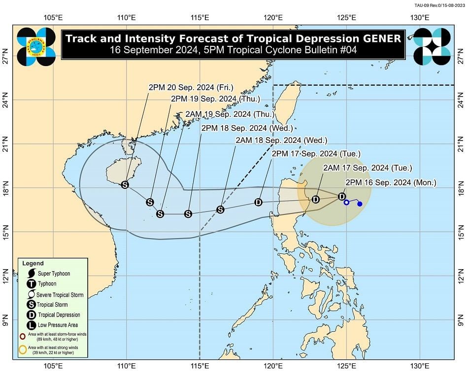
MANILA — Tropical Depression Gener was last located 290 kilometers east of Tuguegarao City, Cagayan, as it continues to approach Northern Luzon, according to the 5 p.m. bulletin from the Philippine Atmospheric, Geophysical and Astronomical Services Administration (PAGASA).
Gener is currently packing maximum sustained winds of 55 km/h near its center, with gusts reaching up to 70 km/h and a central pressure of 996 hPa.
The storm is expected to make landfall near Isabela or Aurora on Monday night or early Tuesday morning. After making landfall, Gener is likely to emerge over the coastal waters of La Union or Pangasinan by late morning or noon on Tuesday.
Tropical Cyclone Wind Signal No. 1 is in effect in the following 19 areas across Luzon:
- Cagayan including Babuyan Islands
- Isabela
- Quirino
- Nueva Vizcaya
- Apayao
- Kalinga
- Abra
- Ifugao
- Mountain Province
- Benguet
- Ilocos Norte
- Ilocos Sur
- La Union
- Pangasinan
- Zambales
- Tarlac
- Nueva Ecija
- Aurora
- Northern portion of Quezon (General Nakar, Infanta, Real) including Polillo Islands

Gener is forecast to continue moving westward over the West Philippine Sea until Wednesday before shifting to a northwestward direction on Thursday, heading toward southern mainland China.
The tropical depression may exit the Philippine Area of Responsibility (PAR) between late Tuesday evening and Wednesday morning.